Thirsty Places: The Aral Sea
The fourth largest lake on Earth was drained in forty years to grow cotton, and the fishing boats of its ports lie in the sand a hundred kilometres from the water. What happened, what it did to the people who lived there, what a dam built in 2005 brought back, and what the largest man made water disaster in history teaches every irrigated valley since.
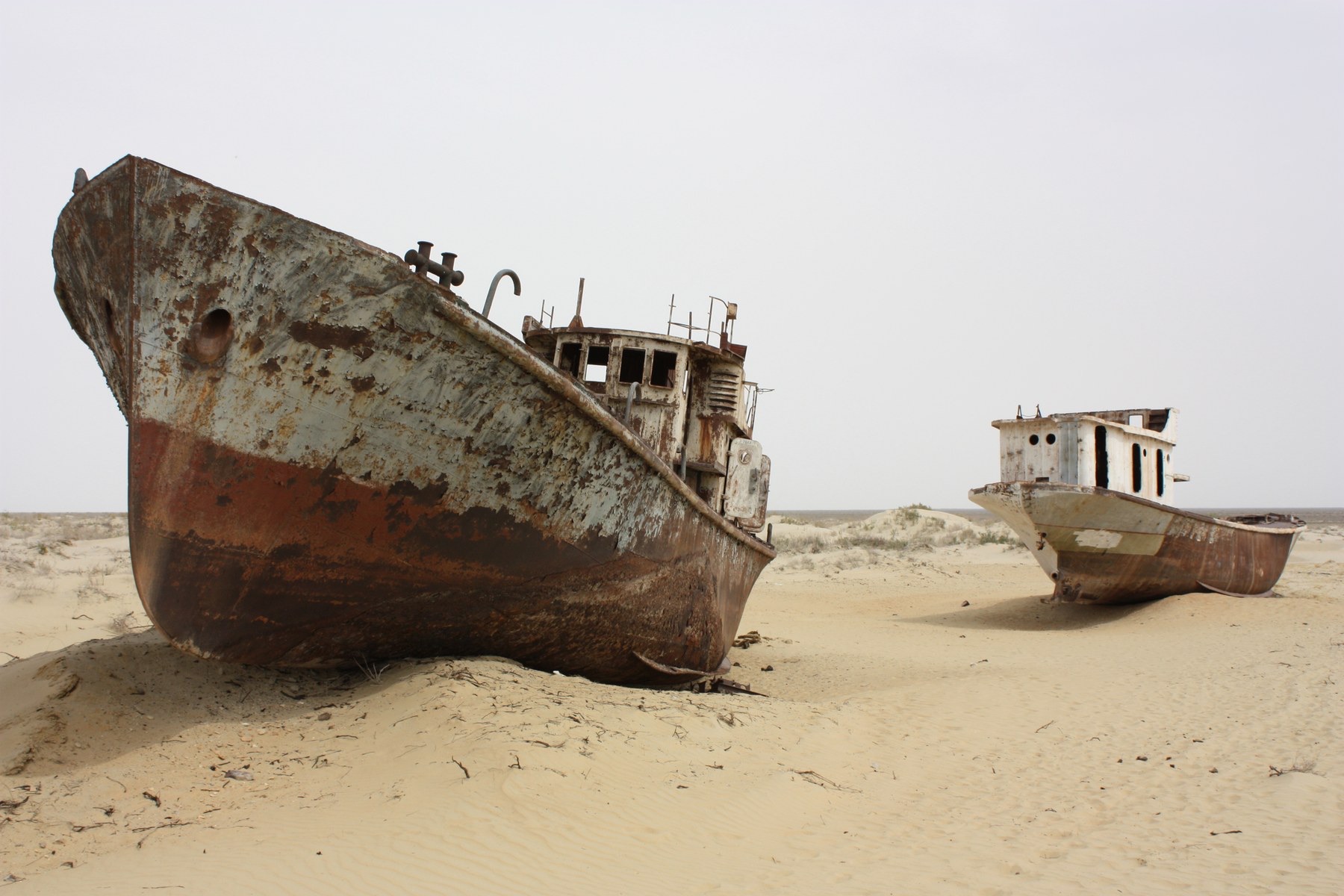
On the northern edge of what used to be the Aral Sea there is a town called Moynaq, and in Moynaq there is a row of fishing boats lying on their sides in the sand. They were not wrecked. They were moored, in a harbour that had been drying out for twenty years, and when the water finally left they stayed where they were. The sea is now about a hundred kilometres away, across a plain of salt and dust that was, within living memory, its bed, and the boats have become a monument that tourists drive out to photograph.
The t-shirt article on this site mentioned the Aral Sea as the clearest picture anywhere of what a supply chain can do to a map. This article goes there.
The sea that was
In 1960 the Aral Sea covered about 68,000 square kilometres between Kazakhstan and Uzbekistan, which made it the fourth largest lake in the world, after the Caspian, Superior and Victoria. It was shallow, brackish, and fed by two great rivers of Central Asia: the Amu Darya from the mountains of Afghanistan and Tajikistan to the south, and the Syr Darya from the Tian Shan to the east. Both rivers crossed hundreds of kilometres of desert to reach it, and had done so for ten thousand years, and the sea's level was the balance between what they brought and what the desert sun took off its surface.
Around it lived fishermen and farmers. The fishing fleet landed tens of thousands of tonnes a year, canned in Moynaq and Aralsk, and the sea moderated the climate of the region, softening the winters and the summers of a landscape that is, without it, one of the harshest on Earth.
| The Aral Sea | 1960 | 2010 |
|---|---|---|
| Area | About 68,000 square kilometres | A tenth of that, in separate lakes |
| Volume | About 1,090 cubic kilometres | About a tenth |
| Salinity | About 10 grams per litre, brackish | Over 100 in the southern basin, saltier than the sea |
| Fish catch | Tens of thousands of tonnes a year | Nothing, until the northern basin returned |
| Distance from Moynaq to the shore | The harbour | About 100 kilometres |
The plan
In the 1950s and 1960s the Soviet government decided to make the deserts of Central Asia grow cotton, on a scale that would make the country self sufficient in the crop and the republics of Uzbekistan, Kazakhstan and Turkmenistan into plantations. The water would come from the two rivers. Thousands of kilometres of canals were dug, the largest of them, the Karakum Canal, carrying a large share of the Amu Darya's flow westward across Turkmenistan, and the fields spread across land that had never been farmed, because it had never had water.
The planners knew what it would do to the sea. The calculations were made, the sea's decline was projected, and it was accepted: a sea in a desert, evaporating water that could grow cotton, was regarded as a waste of the rivers, and the cotton was worth more. The plan worked in its own terms. Cotton production multiplied, Uzbekistan became one of the largest producers in the world, and the rivers, by the time they reached the Aral, were carrying a fraction of their flow. In dry years, by the 1980s, the Amu Darya did not reach the sea at all.
The sea that went
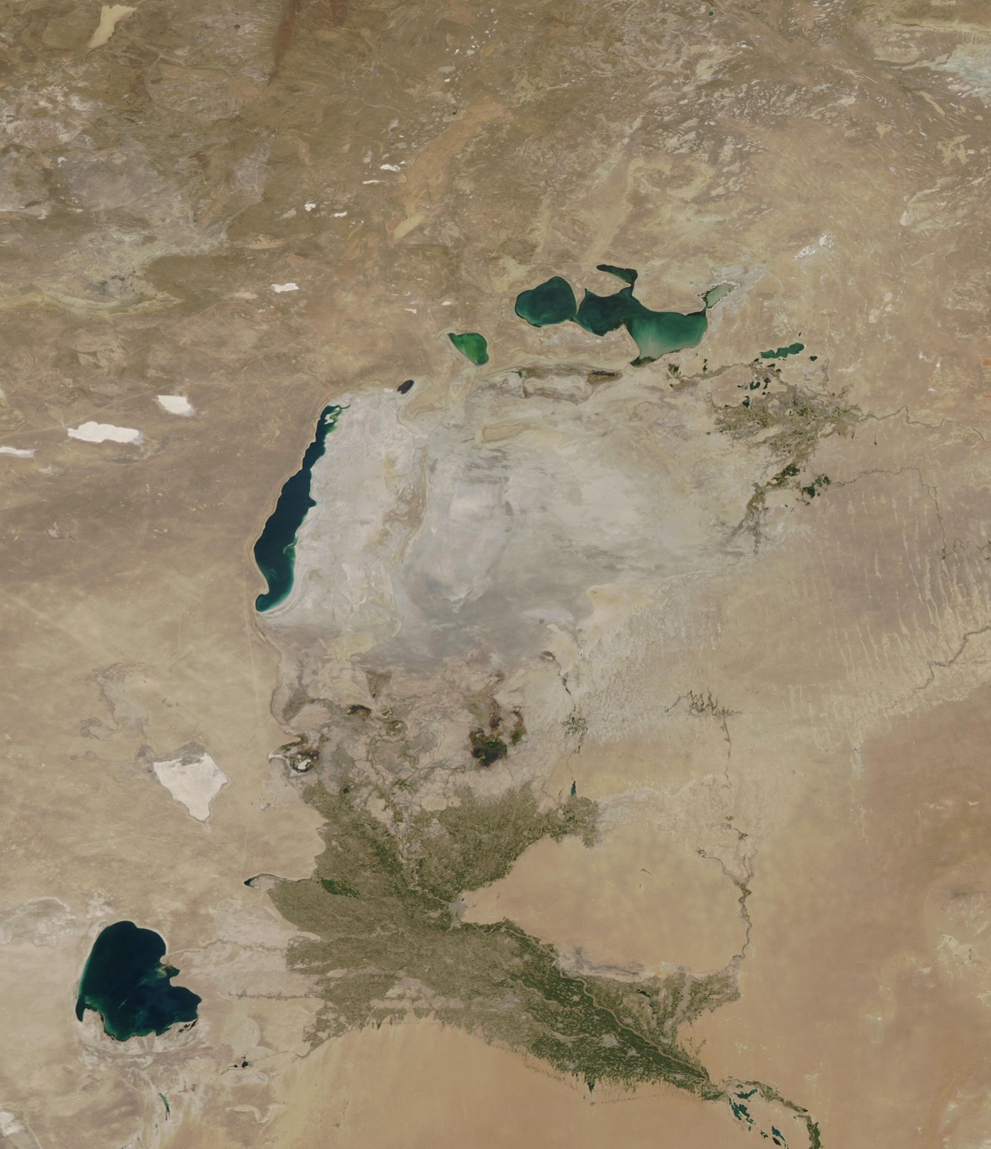
The sea began to fall in the 1960s, slowly, and then faster as the canals took more. By 1987 it had split into two, a small North Aral fed by the Syr Darya and a large South Aral fed, when it was fed, by the Amu Darya. By the 2000s the South Aral had split again, into a western basin along the old shore's cliffs and an eastern basin that was little more than a salt pan, and in 2014, for the first time in modern history, the eastern basin dried completely. Satellite images taken every year since 2000 show the sea shrinking like a puddle in the sun.
What replaced it is a desert with a name, the Aralkum, some tens of thousands of square kilometres of former seabed, and it is a desert unlike others. Its surface is salt, laced with the fertiliser and pesticide residues that four decades of cotton runoff carried into the sea and left behind when the water went. The winds of the region pick it up, and the dust storms that blow off the Aralkum carry salt and chemicals onto the fields and towns for hundreds of kilometres, and, by some measurements, much further. The climate of the region, no longer moderated by the sea, has hotter summers and colder winters than it had. The fishing industry ended in the 1980s. The people of Karakalpakstan, the Uzbek region around the southern shore, have rates of respiratory disease, kidney disease and certain cancers that are among the highest in Central Asia, and the dust is the suspected cause.
What a dam brought back
One part of the story has a different ending, and it is the reason the sea appears on this site in the series about places that solved something.
The North Aral, fed by the Syr Darya, was smaller and shallower, and its water, in the 1990s, was draining south through a widening channel into the dying southern basin, where it evaporated. Kazakhstan, with the World Bank, built a dam across that channel: the Kok Aral dyke, thirteen kilometres of earth and concrete, finished in 2005. The northern basin, no longer leaking south, filled. Its level rose by several metres within a few years, its salinity fell back to what fish could tolerate, and the fish returned, first the hardy ones and then the carp, pike perch and bream of the old fishery. The fishing town of Aralsk, whose harbour had been dry for decades, has boats again, a fish processing plant, and a shore that is closer than it was, if not yet at the old quay.
| The Kok Aral dam | |
|---|---|
| Built | 2001 to 2005, by Kazakhstan with the World Bank |
| Length | About 13 kilometres |
| What it did | Stopped the North Aral draining into the southern basin |
| Result | The northern lake rose several metres, salinity fell, the fishery returned |
| The cost | The southern basin, cut off, dried faster |
The dam saved the north by abandoning the south. The southern basin, which would have received the north's overflow, was left to the Amu Darya, which no longer reaches it, and it has continued to dry. Uzbekistan, on its shore, has planted saxaul shrubs across the seabed by the tens of thousands of hectares to hold down the dust, which is the only thing left to do with it.
The cotton, today
The cotton is still grown. Uzbekistan remains one of the world's larger producers, on the same canals, with the same water, and until recently on the same terms: for decades the harvest was picked by teachers, students and public employees under a state quota, and a coalition of brands boycotted Uzbek cotton for a dozen years over it, until international monitors found in 2021 that the forced labour had ended and the boycott was lifted the next year. The irrigation itself has barely changed. The canals are mostly unlined, and a large share of the water they carry seeps into the desert before it reaches a field, so that the rivers are spent twice, once on the crop and once on the sand. Lining the canals and moving to drip, of the kind the Israel article describes, could return water to the Amu Darya without losing the cotton, and the sums have been done many times. The sea is waiting on them.
The delta and the people
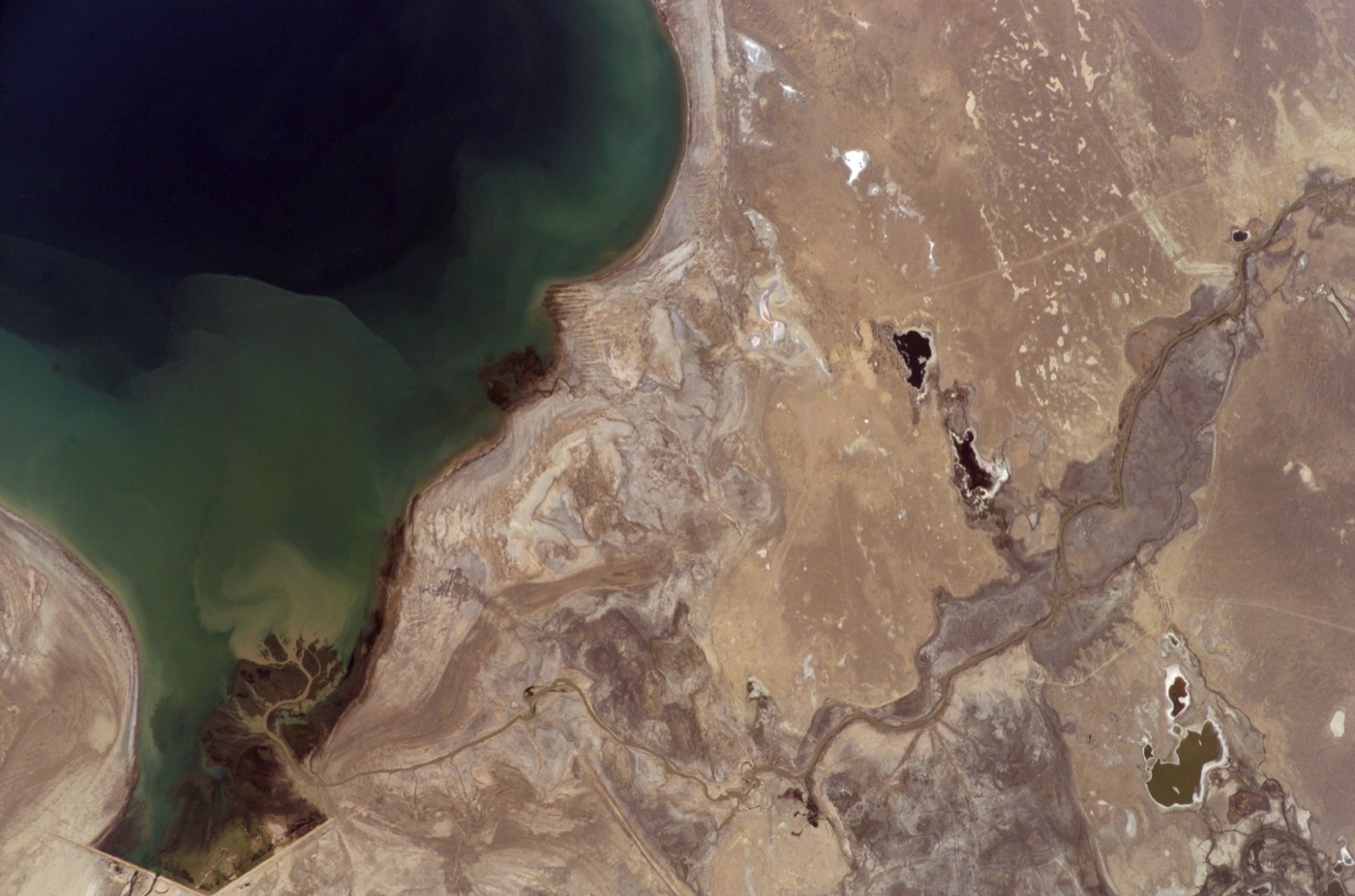
The Amu Darya once ended in a delta of reed beds, lakes and forest, the tugai, at the southern shore of the sea, and the delta was home to fishing villages, muskrat trappers and one of Central Asia's richest wetlands. As the river was diverted the delta dried with the sea, its lakes became salt flats and its forests died, and the people of Karakalpakstan, the Uzbek republic that held it, lost their fishery, their water and much of their farmland to the salt in the same decades. The region has the worst health indicators in Uzbekistan and one of the highest rates of emigration in Central Asia. The Aral Sea is usually told as the story of a lake. It is also the story of a few hundred thousand people who lived at the end of a river that stopped arriving.
What it teaches
The Aral Sea is the largest man made water disaster in history, and its lessons are the plainest on this site.
A river diverted onto a field is water that a lake, a delta or a sea no longer receives, and the method this site uses, with its blue water, exists to count exactly that. The Aral was spent rather than lost to drought or climate: deliberately, on cotton, by planners who did the sums and chose the cotton, and the cotton is still grown, on the same canals, with the same water, today. Every irrigated valley since, in India, in Australia, in California, has faced a smaller version of the same choice, and the Aral is the picture of what the choice looks like when it is made all the way.
And the north shows the other thing. A dam, a decision and ten years brought back a lake that everyone had written off, with fish in it and boats on it. The water was never gone. It was going somewhere else, and when the somewhere else was stopped, it came back. That is a hopeful fact, at the edge of a very large sad one, and it is the reason the sea belongs in this series rather than only in the article about a t-shirt.
Sources
- Micklin, P. (2007). The Aral Sea disaster. Annual Review of Earth and Planetary Sciences 35. The history of the diversion, the shrinkage, and the ecological and human consequences.
- Micklin, P. (2016). The future Aral Sea: hope and despair. Environmental Earth Sciences 75. The Kok Aral dam and the North Aral's recovery; the drying of the eastern basin in 2014.
- UNEP (2014). The Aral Sea: a lake that is dying. Global Environmental Alert Service.
- World Bank, Syr Darya Control and Northern Aral Sea Project (2001 to 2005), the Kok Aral dyke.
- NASA Earth Observatory, the Aral Sea 2000 to 2018, satellite imagery of the shrinkage.
- Photographs: opener, Moynaq, Aral Sea (6226807306) by Arian Zwegers (CC BY) via Wikimedia Commons; inline: Aral Sea 2021 by NASA (public domain) via Wikimedia Commons; inline: ISS015-E-27541 - View of Earth by Earth Science and Remote Sensing Unit, L (public domain) via Wikimedia Commons.