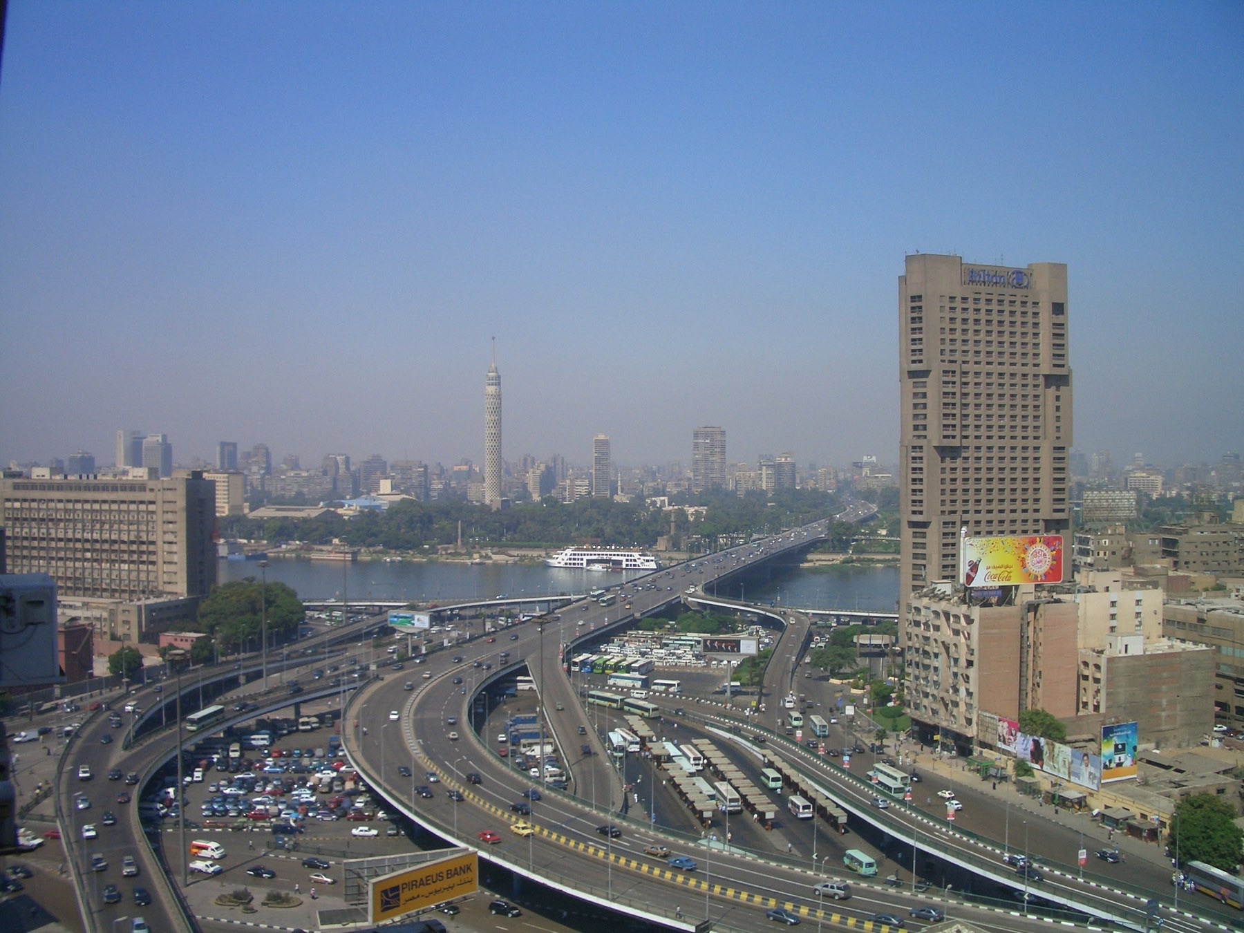
Thirsty Places: Cairo
A country of a hundred and ten million people, almost all of them living on a strip of river valley that is three percent of its land, drinking a river that starts in another country, which has just finished the largest dam in Africa across it. What the Nile is to Egypt, what the Grand Ethiopian Renaissance Dam changes, why the delta is salting and sinking, and what a city of twenty million does when the only river is spoken for.
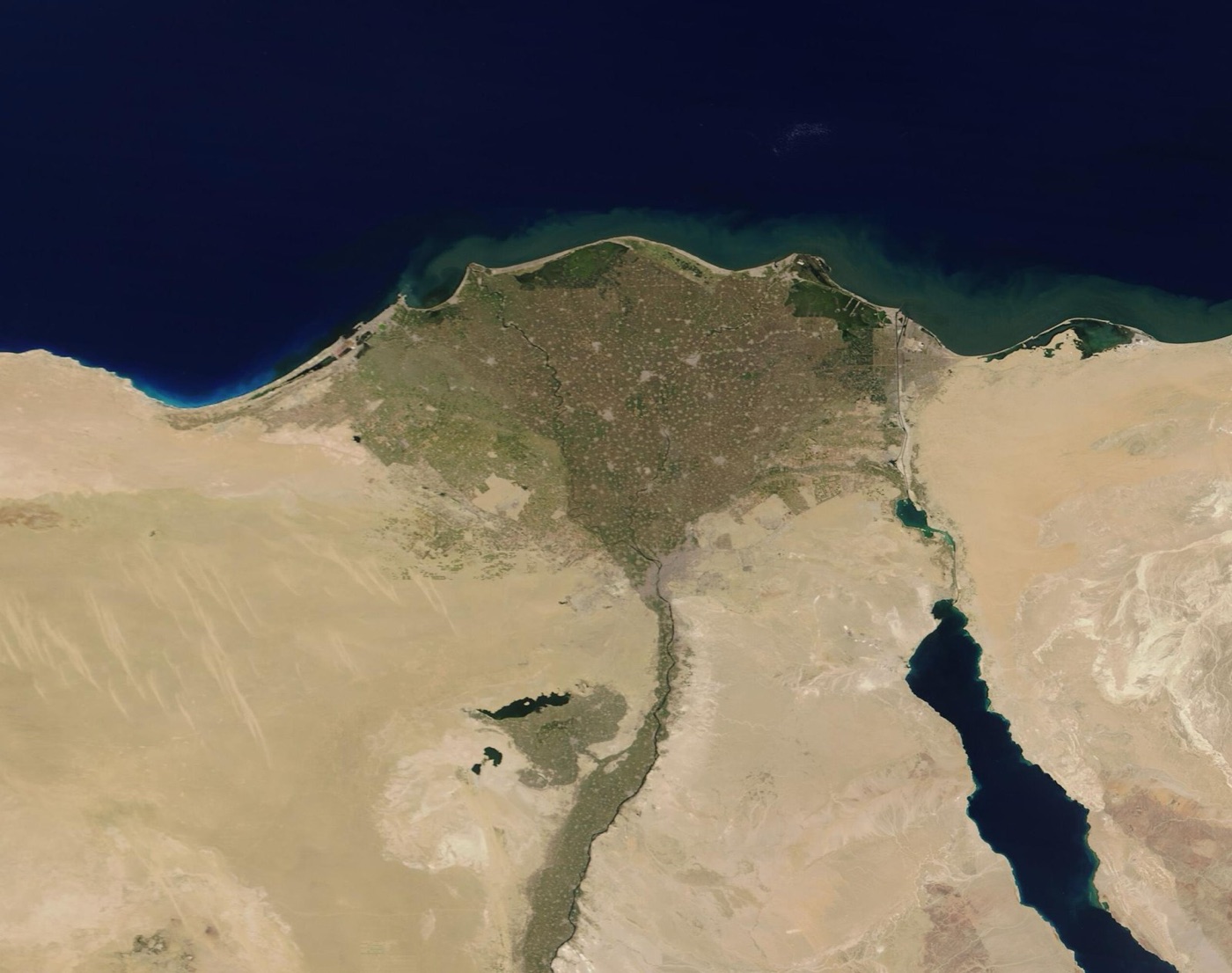
From an aircraft window at night, Egypt is a single line of light. The Nile valley, a strip of green a few kilometres wide, runs a thousand kilometres from the Sudanese border to the Mediterranean and opens into the fan of the delta, and on that strip, three percent of the country's land, live almost all of its hundred and ten million people. On either side of the line is desert, black from the air, and the line is there because the river is. Egypt has no other water worth the name. Ninety seven percent of what the country drinks, grows and manufactures with is the Nile, and the Nile is not Egypt's. It falls as rain on the highlands of Ethiopia and flows through Sudan, and in 2023 Ethiopia finished filling a dam across it that can hold more than a year of its flow.
This article is about a capital of twenty million people at the end of a river that another country now controls, and about what Egypt has begun to do about it.
A river from elsewhere
The Nile is two rivers. The White Nile rises in the lakes of East Africa and crosses the swamps of South Sudan, where it loses half its water to evaporation and arrives at Khartoum steady and small. The Blue Nile rises in the Ethiopian highlands, where the summer monsoon drops most of a year's rain in three months, and it arrives at Khartoum in a flood that carries the silt and, with its neighbour the Atbara, about eighty five percent of the water that reaches Egypt. The river that made Egypt is an Ethiopian river with an East African base flow.
Egypt has treated it as its own for a century. A treaty with Britain in 1929 and one with Sudan in 1959 divided the whole river between the two downstream countries, 55.5 billion cubic metres a year to Egypt and 18.5 to Sudan, and gave Egypt a veto over upstream works. Ethiopia, which supplies the water, signed neither and recognises neither, and for most of the twentieth century it was too poor and too unstable to build anything on the river anyway. That changed in 2011.
| Egypt's water | |
|---|---|
| Population | About 110 million, on about 3 percent of the land |
| Share of fresh water from the Nile | About 97 percent |
| Egypt's treaty share | 55.5 billion cubic metres a year |
| Water per person per year | Under 600 cubic metres, and falling; the scarcity line is 1,000 |
| Share of the Nile at Aswan from Ethiopia | About 85 percent |
| Share of Egypt's water used by farming | About 80 percent |
The dam
The Grand Ethiopian Renaissance Dam stands on the Blue Nile a few kilometres from the Sudanese border, and it is the largest dam in Africa: a wall nearly two kilometres long holding a reservoir of 74 billion cubic metres, more than a year of the Blue Nile's flow, with turbines that will double Ethiopia's electricity. Ethiopia began it in 2011, during the Egyptian revolution, filled it in stages through the wet seasons of 2020 to 2023, and declared it complete in 2025. Egypt objected at every stage, took the dispute to the Security Council and the African Union, and spoke, more than once, of it as a matter of survival. Talks on how the dam should be operated, which the three countries have held for a decade, have produced no agreement.
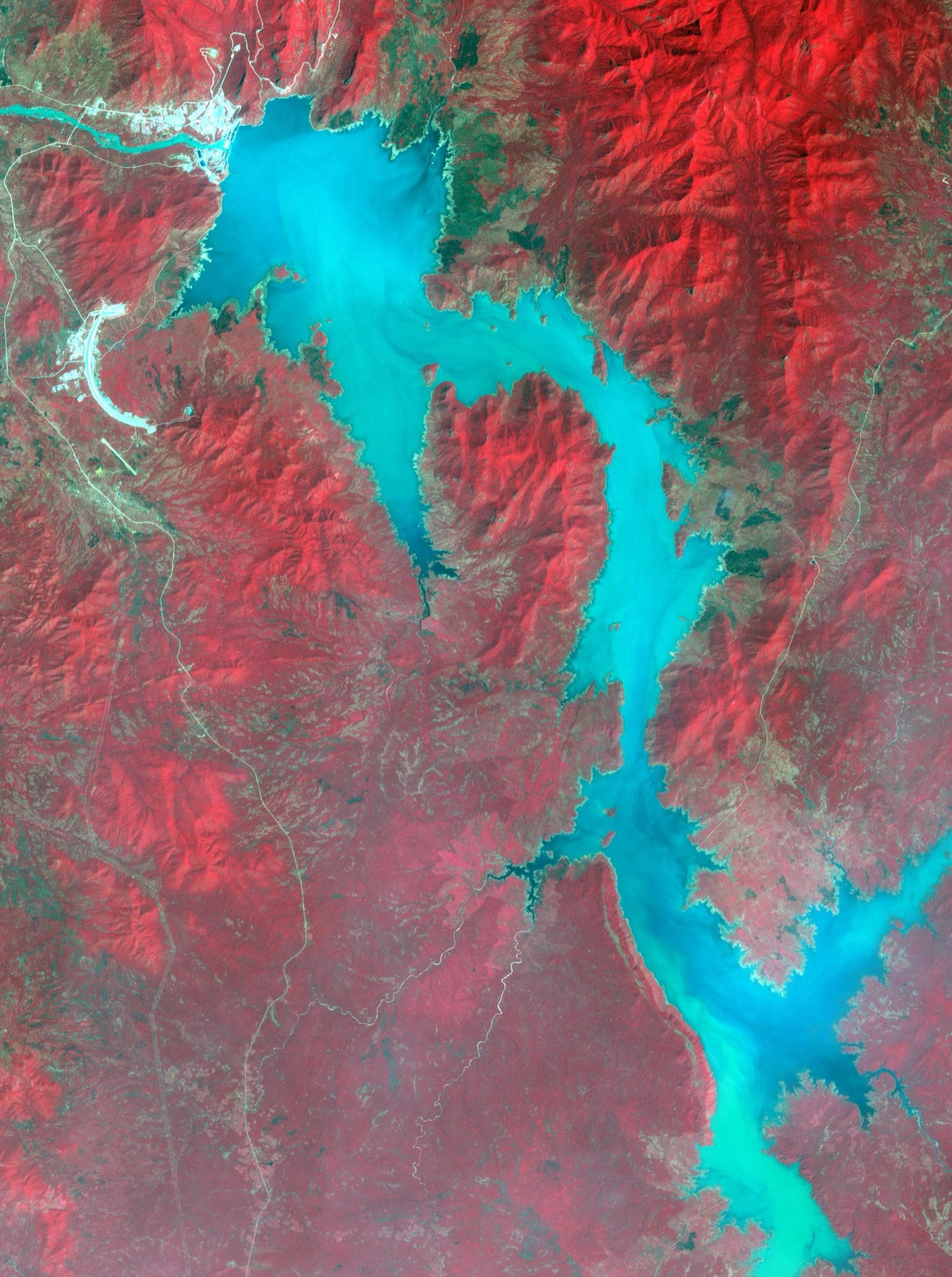
What the dam does to Egypt's water is more subtle than the rhetoric on either side. A hydroelectric dam passes water through its turbines rather than consuming it, and once the reservoir is full, in a normal year, roughly the same water reaches Sudan and Egypt as before, spread more evenly across the seasons, with less silt. The filling took some water out of the river for a few years, and Ethiopia filled it in wet years when the loss went unnoticed. Evaporation from the reservoir's surface takes a share every year, a billion or two cubic metres, which is real and small beside the river.
What the dam changes is a drought. The Nile's flow varies by half from year to year, and in a run of dry years Egypt has always drawn down Lake Nasser, its own reservoir behind the Aswan High Dam, to cover the shortfall. With a second reservoir upstream, the question of who draws down first, and by how much, is decided in Addis Ababa, and if Ethiopia keeps its reservoir full to protect its electricity while the river fails, Egypt's own reserve empties faster than it can refill. That is the scenario the modellers have studied, and it is the one the negotiations are about: a set of rules for dry years that Ethiopia has not agreed to write down.
| The Grand Ethiopian Renaissance Dam | |
|---|---|
| Reservoir | 74 billion cubic metres, more than a year of the Blue Nile |
| Capacity | About 5 gigawatts, doubling Ethiopia's electricity |
| Built | 2011 to 2025; filled 2020 to 2023 |
| In a normal year | Roughly the same water reaches Egypt, with less silt |
| In a drought | Egypt's share depends on Ethiopia's operating rules, which are not agreed |
| Agreement | None, after a decade of talks |
The delta
The dam's silt is the second problem, and it is an old one. Until 1964 the Nile flooded every summer, spread across the valley and the delta, and left a layer of Ethiopian mud that had built the delta over ten thousand years and fertilised Egypt's fields every year. The Aswan High Dam ended the flood, held the silt in Lake Nasser, and gave Egypt year round irrigation and electricity in exchange. The delta has been shrinking since.
Without the river's mud the delta no longer grows seaward, and the Mediterranean, which was held back by a coast that was being rebuilt every year, has been eating it, in places by tens of metres a year. The land itself is sinking, as the young sediment compacts and the groundwater beneath it is pumped, at a few millimetres a year, and the sea level is rising. Salt water pushes inland through the aquifer and up the drainage canals, and the northern delta's fields, which grow a large share of Egypt's rice, wheat and vegetables, are turning saline from below. A third of the delta lies less than a metre above the sea, and the projections for the end of the century put a large part of it under water or too salty to farm.
The Ethiopian dam adds to this by holding more of what silt the river still carries, and by regulating the flow so that the delta's channels, which the flood used to scour, silt up and shrink.
The city
Cairo is where the valley meets the delta, and it has grown from two million people in 1950 to more than twenty million in the metropolitan area, on water drawn from the same river that irrigates the fields around it. The city's supply is taken from the Nile at intakes along its length, treated at large conventional plants of the kind the coagulation and disinfection articles describe, and piped to a network that loses, by the utility's estimate, a third of it. The water that reaches the tap is safe, in most of the city, and it is scarce, in the sense that the city's share competes with the farms' and the farms take eighty percent of the country's water.
The sewage went, for most of the city's history, into the drains and canals of the delta, which carried it, untreated or barely treated, to the fields and the northern lakes. Cairo has built, since the 1990s, one of the larger sewage treatment systems in the developing world, and in 2021 it opened, in the eastern delta at Bahr al Baqar, the largest agricultural drainage treatment plant on Earth, which takes the drain water of the delta, five and a half million cubic metres a day, treats it, and pipes it under the Suez Canal to irrigate a new farming region in the Sinai. A second plant of similar size, the New Delta, opened in 2023 on the western edge. It is reuse at the scale of the Orange County article multiplied by twenty, and it is the country's answer to a river it cannot enlarge.
| What Egypt is building | |
|---|---|
| Bahr al Baqar, 2021 | 5.6 million cubic metres a day of treated drainage water, to the Sinai |
| New Delta, 2023 | About 7.5 million cubic metres a day, to new farms west of the delta |
| Desalination | About 90 plants on the coasts, with a programme for several million cubic metres a day |
| Canal lining | Thousands of kilometres of earth canals lined to stop seepage |
| Rice | Acreage capped, to cut the thirstiest crop |
The farms
Eighty percent of Egypt's water goes to its fields, and the fields are the margin. The valley and the delta grow wheat, maize, rice, sugar cane, cotton, clover for cattle, and the fruit and vegetables that Egypt exports to Europe in winter, on irrigation from the river through a canal system that the pharaohs began and the British extended. Much of it is still flood irrigation, in earth canals that lose a share of their water to seepage and evaporation before it reaches a field, and the government has spent the last decade lining the canals, tens of thousands of kilometres of them, and pushing farmers to drip and sprinkler on the crops that can take it. Rice, the thirstiest crop and one that Egypt grows more of than its water allows, has had its area capped and the cap enforced by satellite. And the new farms in the Sinai and the western desert, the ones fed by the treated drainage water of the new plants, are drip from the start. The arithmetic is plain: a tenth saved on the farms is more than the dam will ever take in a normal year, and it is the only water in the country that Egypt controls.
What it teaches
Egypt is the extreme case of a country that lives on a river it does not own, and the Ethiopian dam has made that condition visible in a way that a century of treaties concealed. The water will mostly still arrive; the decision about how much arrives in a bad year has moved upstream, and no agreement governs it. What Egypt has done in response is what every place in this series has done when the river is spoken for: treat and reuse its wastewater at a scale nobody else has attempted, desalinate its coasts, line its canals and cap its rice. It is buying, with those works, the margin that the treaties no longer provide.
Ninety seven percent from one river, eighty five percent of that from one neighbour, and a dam across it with no rules for the dry year.
Sources
- Egyptian Ministry of Water Resources and Irrigation, National Water Resources Plan 2037: the Nile's 55.5 billion cubic metre share under the 1959 agreement, and per capita availability below 600 cubic metres.
- Wheeler, K.G. et al. (2020). Understanding and managing new risks on the Nile with the Grand Ethiopian Renaissance Dam. Nature Communications 11.
- Stanley, D.J. and Warne, A.G. (1993). Nile Delta: recent geological evolution and human impact. Science 260. Delta subsidence and coastal retreat since the High Dam.
- Nile Basin Initiative, State of the Basin reports: the Blue Nile's share of the flow at Aswan, about 85 percent including the Atbara.
- Reporting by Reuters and Al Ahram on the Bahr al Baqar and New Delta treatment plants and the coastal desalination programme, 2021 to 2024.
- Photographs: opener: Cairo and Nile Skyline by Staeiou (CC BY-SA) via Wikimedia Commons; inline: Grand Ethiopian Renaissance Dam (ASTER) by NASA/METI/AIST/Japan Space Systems, and (public domain) via Wikimedia Commons; inline: Nile River Delta (MODIS 2021-05-26) by MO'DIS Land Rapid Response Team, NASA GS (public domain) via Wikimedia Commons.